
Utilising drones in Search & Rescue operations
Even in the harshest of conditions, our commercial drone solutions are designed to effectively identify and locate those in need. By utilising aerial technology, Public Safety personnel are able to position themselves in a safe zone while assessing a situation from above and planning their next course of action. Where reliability is imperative, our fleet of industrial-strength drones and cameras will operate in a wide range of conditions while remaining lightweight and portable, ready to be deployed exactly when and where they are needed.
For more information on how we can help with your project, contact our Commercial Solutions team via the contact form below.
How are drones saving lives in Aotearoa New Zealand?

YSAR NZ performing drone training for their recruits.
Search and Rescue
Search and Rescue teams often need to navigate through vast, challenging and dangerous terrain to save the lives of others. In these operations, drone technology is utilised to quickly and effectively assess the scene and locate those in danger without risking members of the team.
Unlike helicopters, UAVs have the ability to be easily deployed, quietly gliding over elevated landscapes to locate individuals. High-powered thermal and zoom cameras allow teams to identify heat signatures through thick brush and snow, then take a closer look for confirmation.
UAVs truly show their strengths in disaster situations. With a live visual feed of large disaster areas, incident commanders can make informed decisions to effectively direct on-the-ground teams and communicate the situation to off-site stakeholders.
In sea rescues, search teams can use thermal and zoom cameras to sweep large bodies of water even in low visibility, locate heat signatures, and initiate a rescue.
Ferntech works with volunteer SAR organisations to provide craft for training the heroes of tomorrow.

Thermal imagery software helps assess hotspots and pinpoint danger zones.
Fire & EMERGENCY
Firefighters dedicate their lives to saving others, but often they only have seconds to make critical decisions when they arrive on scene. Employing drone technology can help firefighters respond quicker while also keeping them safe.
With an overhead view of the scene, firefighters can access real time information about exits and entry points as well as revealing information about the nature of the fire that might not otherwise be possible to gather. Drones with thermal imaging cameras can be deployed for thermal hotspot inspection to assess and pinpoint the danger zones and unseen smoldering on the site. Thermal imaging can also help to locate people who might be trapped in hard-to-access areas, so that firefighters can focus their efforts on saving them.
As part of preventive action plans, firefighters in the US have been employing drones to capture data and create orthomosaic maps of key buildings and facilities, like schools, within their local area to gain pre-determined situational awareness. Collecting aerial data for orthomosaic maps can also be helpful when the fire is active for post-fire analysis, investigations, surveys and training.

Our team advising local police in Palmerston North on drone technology.
Police
Police are regularly involved in search and rescue missions when there is a potential threat to people’s lives. In dangerous or hard-to-reach places such as cliffs or gulleys, drone technology enables officers and rescue workers to quickly get invaluable intelligence with an aerial overview — without compromising their own safety.
Police can deploy drones early in operations to gather information and intelligence about the incident that the team may be facing —minimising risk for the public and those involved in the incident while maximising the safety of the officers.
Aerial imaging is often utilised when the scene needs to be mapped from a distance due to safety or tactical reasons. Teams use the data to gain insights that enhance the effectiveness of deployment and tactics plans. For example, determining the presence of civilians within a given area, the exact location of the subject and whether he or she is armed — or even spotting an escape route or vehicle nearby. Drones are also employed for photographing scenes and surveillance operations.
We work with Police units across New Zealand to help them find the right solution for their needs.

NSW lifeguards utilise drone technology to save lives.
Surf Rescue
UAVs provide an extra set of eyes for greater coverage of dangers along the coast and a faster response to incidents at key blackspot locations. The drones are predominantly used to provide aerial vision and surveillance to help spot rips and swimmers in distress. With the addition of a customisable loudspeaker, lifesavers can send messages to those swimming too far out.
Case studies from New South Wales have shown the effectiveness of the drones in lifesaving operations, and show that with funding support UAVs can become a vital part of the tools used by surf lifesavers every summer.
CASE STUDY
Industry leaders demonstration in Palmerston North
Our team spent the day in Rangitikei talking to industry leaders about the current and potential applications for drones in public safety. The attending group from Horizons Regional Council, Palmerston North CC, Fire and Emergency, St John, Rangitikei District Council and ASMS were given the full rundown from our team and pilots within the industry, such as Paul Chaffe from Civil Defence. The crew then got the chance to see the drones in action with live demonstrations. Watch the video below.
Our key products for Public Safety

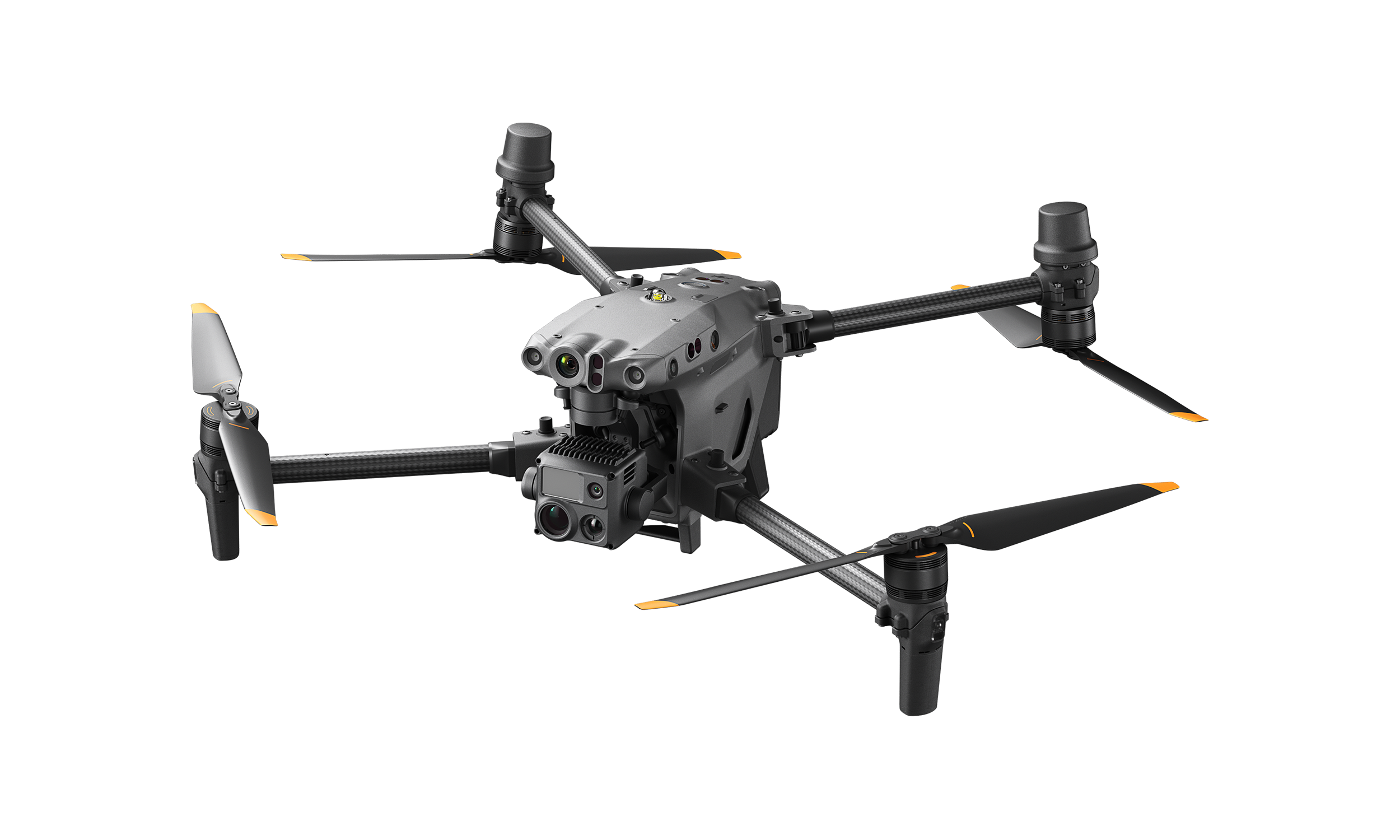
DJI MATRICE 30 SERIES
The DJI Matrice 30 is DJI Enterprise's flagship drone that fits in a backpack. It integrates multiple high-performance sensors into one single camera payload, is controlled with an ingenious redesigned remote control and runs on upgraded Pilot 2 software, which significantly improves the flight experience. The M30 model offers much more power, endurance and capability for rugged professional uses, while its size makes it ideal for easy transportation and fast setup.
Apart from its outstanding performance and new format, the DJI M30 allows professionals to fly and perform beyond their immediate surroundings. It integrates smoothly with the new DJI FlightHub 2 fleet management cloud-based software and the DJI Dock for collaboration with remote and unattended operations, bringing efficiency innovation to various industries.
The M30 series comes in two versions, the M30 and the M30T. The M30 model integrates a 48 megapixel 1/2'' CMOS sensor zoom camera with 5×~16× optical and 200× digital zoom, a 12 megapixel wide-angle camera, 8k photo 4K/30 fps video resolution, and a laser rangefinder which can give the precise coordinates of objects up to 1,200 meters away. The M30T features an additional 640x512 px radiometric thermal camera.
Get Quote

DJI MATRICE 300 RTK
Offering up to 55 minutes of flight time, advanced AI capabilities, 6 Directional Sensing & Positioning and more, the DJI MATRICE 300 RTK sets a whole new standard by combining intelligence with high-performance and unrivalled reliability.
The DJI Matrice 300 RTK is an excellent tool for specific tasks such as Firefighting, where the use of its radiometric thermal camera can provide accurate intelligence real-time when fighting fires and saving lives without endangering personnel. In Search and Rescue, where time is critical, the Matrice 300 RTK can act quickly to locate missing people and help to create a better plan for a rescue mission.
The M300 RTK and Zenmuse H20 series are available in New Zealand at Ferntech Commercial.
Get Quote
Complete Solutions
Public Safety SOLUTION
A compact and user-friendly aerial platform that can be optimised for a range of use cases.
Solution includes:
Matrice 30T
Customised Training Programme from Ferntech
Get Quote
Frequently Asked Questions
I’m not very tech-savvy. Do you offer any support to help me start flying a drone?
Our team are on hand to help you make the most of your drone. Give us a call during store hours from Monday to Saturday and we will talk you through whatever you want to achieve. Keep an eye on our website and Facebook for upcoming training events.
What weather conditions can I operate a drone in?
DJI drones are some of the most capable craft when flying in wind. For example the Mavic 2 is rated to fly in winds up to 38Kph and the Matrice 200 up to 43Kph.
The Matrice 200 is also IP43 rated, along with the XT2 thermal camera, which means you are able to fly and perform operations even in rain up to 10mm per hour.
The Matrice 200 series can operate in temperatures down to -3 degrees celsius, with its self heating TB50 batteries it will be ready to fly even in the harshest of conditions.
I need something compact, lightweight and easy to deploy, what would suit?
Definitely the Mavic 2 series. This is by far the most versatile and packable craft in the DJI range. There are a few versions available starting from the Mavic 2 Zoom with its 2x optical zoom 12MP camera, up to the Mavic 2 Enterprise Dual with its FLIR Lepton thermal sensor along side a 12MP visual camera, there is an application for every situation. Even better that the craft with battery on board only weighs approx. 900g and the controller is lightweight and compact, so packing is a breeze.
How can a thermal camera find a person of interest easily?
DJI’s thermal imagers make use of a feature called “Isotherms” where you are able to highlight objects which fall within a certain temperature range. This means that employing the drone in a search and rescue situation to identify objects or persons of interest is fast and simple. The audible “heat alarm” is also a useful tool that can be set to alert the pilot when a certain temperature object is present.
I need to share visual information with my team, how can this be achieved?
With the use of the Mavic 2 combined with DJI Smart Controller, or the M200 series of craft, you have the option of an HDMI output from the transmitter. This makes it easy to relay visual information from the drone to a monitor which can be supervised by other team members.
DJI craft also have the ability to live feed video via RTMP, considering the pilot has a reliable data (4g) connection on site. This means visual information can be relayed back to base or anyone who may have an interest in the operation planning and management.
What if I need to map an area of interest?
You could employ the Phantom 4 RTK craft which is specifically designed to capture aerial imagery for the sole purpose of 2d or 3d mapping the area flown. What the RTK system can achieve is a highly accurate geolocation of any part of the processed map so measurements or exact locations can be recorded. This would be an ideal solution for scene mapping or scouring a large area to assess the topography of the scene.
We are a rural volunteer fire service. What drone would you suggest for a smaller operation?
Any fire service would see the advantage of a thermal imaging capable drone, so the Mavic 2 Enterprise Dual would be the ideal tool. With its on-board thermal camera, rural fire services will be able to use this drone to identify fire hot-spots and assess situations before sending in the firefighters.
Can I fly the drone at night?
Yes you can, but be aware of local regulations regarding night operations of drones. If operating under CAA Part 101 rules, you are only able to perform shielded operations between sunset and sunrise. Anything in between will need to be approved by a part 102 organisation.
What training do you suggest for operating a drone for search and rescue?
We highly recommend completing at least a CAA Part 101 certificate which can be obtained from an organisation such as ASMS or any other part 141 certified trainer. With this qualification you will be able to operate with permission within some restricted flight areas and gain a higher understanding of the rules and management of flying drones.
In what situations would I benefit from having a Matrice rather than a Mavic?
Because the Matrice 200 series is a much larger craft, and holds an IP43 weather resistance rating, you will be able to operate the Matrice 200 in a much wider range of conditions. On top of this, the Matrice 200 has the ability to carry more camera options, including the Zenmuse Z30 with a 30x optical zoom capability, and the XT2 Thermal which integrates a FLIR Duo.
What kind of accessories should I get for my drone?
The essential accessory for any drone owner is extra batteries so that you can fly for longer time periods. Although this is our first recommendation, there are many other options which can help to enhance your drone operation. A charging hub, for example, means you can throw multiple batteries on a charger at the end of the day and have them ready for the next day’s work. You can also purchase tablet holders so that you can hold a larger screen for viewing the live feed from the drone, as well as sun shades to help keep the glare off your screen.
To see more accessories available for your drone choice, please visit ferntech.co.nz and see what is available for your craft.
How many batteries should I get?
Two or three batteries would be ideal for a decent amount of flying time. On average, a Mavic 2 Enterprise will fly for 25 minutes per battery. The maximum flying time is 31 minutes, but this is in perfect conditions and tested at a certain speed of flight. Keep in mind that a drone can cover a vast amount of ground very quickly, so a 25 minute battery life may not sound like much, but you can achieve a lot in that time.
What are the rules for where I can fly a drone?
Please visit www.flyyourdrone.nz or www.airshare.co.nz to find out more about where you can and cannot fly your drones.
Why buy from Ferntech?
By buying from Ferntech, you'll have the confidence that you are dealing directly with New Zealand's leading drone specialists. Our team are knowledgable drone pilots who offer expert advice, trusted support and superior specialist service. Only through us will you receive a full New Zealand warranty, phone and email support, and access to our certified Repairs Centre with DJI-qualified drone technicians. And we guarantee that we will have the best prices on the market — if not let us know and we will match any price (some conditions apply).
Born in Christchurch in 2013, we are a proud local Kiwi business.. Our team work hard to ensure that drone technology is helping individuals, businesses and organisations across New Zealand to achieve what was once out of reach.